Services
Marine
Discover the Sky’s Canvas: Marine Aerial Photography Services
I specialize in capturing the essence of maritime beauty from a bird’s-eye view. My aerial photography services elevate your boat or yacht experience, providing you with stunning visuals that leave a lasting impression. Whether you’re a boat owner, charter company, or marketing professional, I’ve got you covered.
Sunset Serenity: Witness the magic of sunsets like never before. I will accompany you during golden hour, capturing your vessel against a breathtaking backdrop. Imagine your boat silhouetted by warm hues, reflecting on tranquil waters. These high-resolution sunset shots are perfect for framing or sharing with fellow enthusiasts.
Unique Perspectives: Marketing your boat? Let me provide fresh angles that set you apart. From top-down shots highlighting sleek lines to water-level perspectives emphasizing stability, these images tell a compelling story. Use them in brochures, websites, or social media campaigns to attract potential buyers or charter clients.
High-Resolution Imagery: I don’t compromise on quality, my drone captures every detail, from the glimmering deck to the billowing sails. Expect crisp, vibrant images that showcase your boat’s character and craftsmanship.
Why Choose Me?
Passion: I am not just a drone photographer; I am a boat enthusiast. I share your love for the open water!
Professionalism: Timely delivery, personalized service, and attention to detail define my work.
Tailored Packages: Whether you’re a solo sailor or a fleet owner, I customize my services to meet your needs.

Harbor View
Ideal for boat owners who want captivating shots as they set sail.
Includes 5-10 edited aerial photos.
Perfect for capturing the excitement of leaving the dock and the marina.
Price: $150
Horizon Explorer
Join you on your boat for an unforgettable photography session.
Aerial and water-level shots showcasing your vessel’s elegance.
Includes 15-25 edited photos.
Price: $350
Golden Waves
Experience the magic of golden hour on your boat.
Aerial shots against a stunning sunset backdrop.
Capture the serenity of water and sky.
Includes 15-25 edited photos.
Price: $400
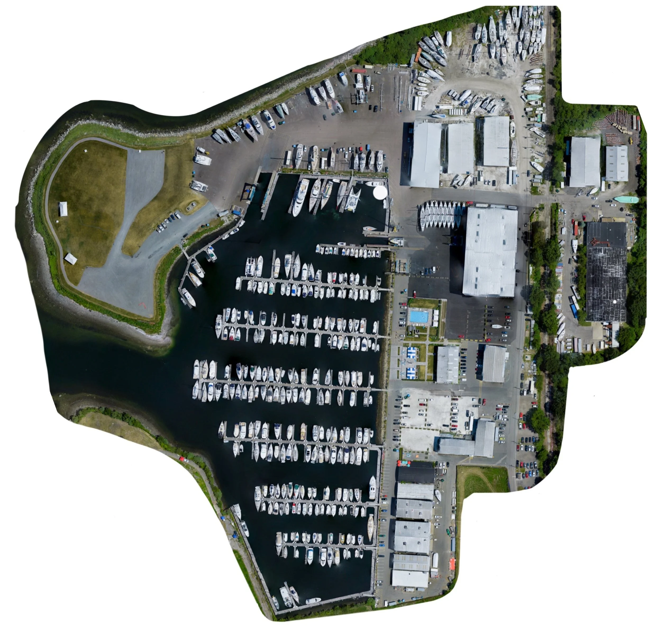
Orthographic Mapping
Orthographic mapping is a cutting-edge process that transforms hundreds of aerial images into precise, distortion-free maps, ideal for surveying, planning, and analysis. I ensure high-accuracy results tailored to your project’s needs.
I can also provide 3D textured maps, Point Cloud maps, Digital Elevation Maps, and Plant Health Maps.
Pricing starts at a $500 minimum for areas below 12 acres.
Areas above 12 acres start at $40 per acre.
IMPORTANT INFORMATION

Restricted Airspace
Unfortunately, a significant portion of the water east of Aquidneck Island falls within the restricted airspace of Quonset State Airport. This airport serves both the Air and Army National Guard, and their safety protocols enforce a 5 NM (nautical mile) radius around the airport.
The restricted airspace includes the entirety of Prudence Island, Potter’s Cove, and the northern area of Jamestown, extending north of the Newport Bridge. Additionally, the Newport Naval Base also has restricted airspace.
As a result, I am limited to where flights on the west side of Aquidneck Island can be conducted—specifically, the area north of Safe Harbor New England Boatworks and south of the Newport Bridge. However, I am actively pursuing an FAA waiver to operate within this airspace. Please understand that the waiver process may take several months.
I apologize for any inconvenience this may cause, and I remain hopeful that I’ll be able to offer aerial photography services throughout the entire island in the near future. Thank you for your understanding!